Forest expeditions to monitor territories and preserve Indigenous culture
Indigenous environmental agents took part in a series of forest expeditions aimed at mapping and identifying different plant and animal species, some used for the production of traditional medicine and handicrafts; mapping areas rich in fruit trees; and detecting strategic spots in Indigenous lands that are most threatened by invaders.
The expeditions were suspended almost two years ago due to the COVID-19 pandemic, and resumed at the end of last year at the Kanela and Porquinhos Indigenous lands, both located in the state of Maranhão, in the Legal Amazon.
They took place under a project known as Integrated Environmental and Territorial Management in Eastern Amazon Indigenous Lands. All necessary health safety measures were adopted, in particular ensuring vaccination programs reached the communities.
The project is supported by the Partnership for the Conservation of Amazon Biodiversity (PCAB). It was created through a cooperation agreement between USAID/Brazil and the Indigenist Work Center (CTI), and involves the Society, Population and Nature Institute (ISPN), the Wyty-Catë Organization of Timbira Communities of Maranhão and Tocantins, the Maranhão Indigenous Organizations Network (COAPIMA), and the Maranhão Indigenous Women Network (AMIMA).
"Expeditions are a way of sharing experiences, in addition to monitoring the land. Women’s involvement greatly enriched the work, especially for the identification of plants that are relevant for their daily life and rituals. Our focus was also on promoting the production of handicrafts, artifacts and adornments, in addition to helping to find and collect medicinal plants from the Cerrado, traditionally used by the Timbira peoples," explains Pollyana Mendonça, from the CTI.
Together, these two Indigenous lands are home to about 2,700 people. They are located in a transition area between the Amazon and Cerrado biomes, where vegetation is typical of the Brazilian Midwest.
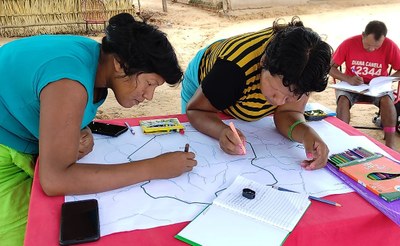
The fieldwork requires participants to spend days walking through the forest. During this time, they produce participatory maps of territorial monitoring and control, and gather geographic and cultural data.
Each Indigenous community chooses their own participants, taking into account both gender and generation diversity. They work together with environmental agents known as Mentuwajê (which means young protectors of the environment), and jointly define the focus of monitoring.
These expeditions are intermodular activities, and are part of the Indigenous environmental agents’ training program. The goal is to promote initial training in participatory mapping using written, audiovisual, and geospatial instruments, aiming to gather environmental information to support Indigenous land maps, and devising monitoring and territorial control strategies together with the communities.
The expeditions covered 900 km (slightly longer than the distance between Washington DC and Lexington) on the Kanela Indigenous land, and 700 km on the Porquinhos land. In all, 20 Indigenous environmental agents took part in the expeditions, including seven women.
Before the fieldwork itself, participants prepared all the materials and supplies they needed for the activity, such as food and safety equipment. They held debriefing sessions with leaders and community members in their villages to present a summary of their routes and experiences. The first expeditions took place in November 2019.
Knowing the land — Through the program, Indigenous women found tiririca (a type of dwarf papyrus that reaches up to 60 cm in height, with very thin leaves. It is used for the production of necklaces and other adornments), and milk trees (locally known as pau-de-leite), used for body painting.
While crossing both Indigenous lands, the groups monitored different landscapes, including mountain ranges, dense forests, riverbanks and tributaries, springs, grasslands, cultivated areas, and old villages, among others.
Along the route, they found recent traces of invaders, as well as signs that boundary markers had been removed, and even armed hunters. There was evidence that forest fires and the illegal removal of riparian vegetation by loggers were silting up springs and drying lakes in the area.
Each Mentuwajê reported their own experiences in their mother tongue. Both teams of Indigenous environmental agents will remain involved in the project, and will carry on this important work.


